Informations générale

Données de base
Varies from 1300 mm/year in Angola to 300 mm/year and 400 mm/year in Namibia and Botswana respectively.
The irrigation potential of this basin is estimated at 210,000 ha. Other: Hydropower development in the lower catchment is limited by relatively flat terrain and sandy soils. Angola has high hydropower potential.
Site Internet
Couverture géographique
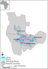
This basin includes the Okavango River with its two tributaries of Cubango and Cuito.
| Pays | Superficie |
|---|---|
|
Angola
|
150100km²
|
|
Botswana
|
358200km²
|
|
Namibie
|
176200km²
|
|
Zimbabwe
|
22600km²
|
Fonction/mandat
OKACOM advises its member states on measures and arrangements to determine the long-term safe yield of water available from all potential water resources in the Okavango River Basin and to anticipate demand; criteria to be adopted for the equitable allocation, conservation, and sustainable utilization of water resources in the basin; investigations, separately or jointly by the contracting parties, related to the development of any water resources in the basin, including the construction, operation and maintenance of any water works and prevention of pollution of water resources and control of aquatic weeds in the basin.
Fonctionnement
The highest organ of OKACOM is the Interministerial committee from member states and two technical members from each state. The Okavango River Steering Committee composed of two members from each state implements the transboundary integrated water resources management.
The agreement of 1994 facilitated the creation of the Permanent Okavango River Basin Water Commission (OKACOM) as a coordinating organization to act as a prime technical advisor to the three member states regarding the conservation, development, and use of water resources of mutual interest. OKACOM has neither a permanent secretariat nor a large staff complement. In its course of action, OKACOM established the Okavango River Steering Committee to implement the Trans-Boundary Diagnostic Analysis. The Committee has two technical members from each riparian state and has the mandate to advise the Commission on all technical matters. Under the umbrella of OKACOM, the member states are jointly working on a proposal to develop an integrated water resources management strategy. In this respect, OKACOM has to overcome major difficulties such as the absence of reliable basin-wide data and the conflicting national perspectives on resource needs.
In order to develop an Integrated Basin Management Plan, the following activities were supposed to be undertaken:
• Trans-Boundary Diagnostic Assessment study to identify key areas of concern and gaps in knowledge of the physical and socio-economic system of the river basin;
• Strategic Action Program to structure inputs and resources prior to the implementation of a larger joint program of action;
• basin-wide Environmental Assessment with the participation of stakeholders including the establishment of channels of communication for effective coordination, consultation, and cooperation among the stakeholders.
In order for OKACOM to fulfill its mandate, the Agreement stipulated that the signatory states supply the Commission with the required information. The signatory states were also required to notify the Commission and each other of any proposed development and before water regulating actions are undertaken.
The Commission defines its own rules of procedure. Decision-making is based on negotiations among the concerned parties and is based on consensus. If no decisions can be made, the matter is referred to the member states for further negotiation. There are no formal sanctioning mechanisms for non-compliance of agreed upon rules and procedures. Any dispute concerning the interpretation or implementation of the OKACOM Agreement was to be settled by the member states.
Each member state bears the costs of its own delegation. The member state hosting a meeting of OKACOM bears the meeting costs. Other costs or liabilities accepted by the Commission in the performance of its functions and the exercise of its power, shall be shared equally by the member states, unless otherwise agreed by the Commission. OKACOM has a small staff complement; it is not an expensive organization which relies on a small budget.
No specific provisions although intensive lobbying has taken place by the Okavango Liaison Group, a coalition of nongovernmental organizations formed in 1996 The International Rivers Network (IRN) has been actively involved in developing this coalition. International actors involved are the IUCN, World Wildlife Fund, Green Cross International and Green Peace.
Before the “Agreement on the Establishment of a Permanent Okavango River Basin Water Commission” was signed by the three riparian states in 1994, only bilateral agreements existed. In September 1990, the governments of Angola and Namibia agreed to endorse and affirm the old agreement on the Kunene River, signed between the colonial powers of Portugal and South Africa and to re-establish the Permanent Joint Technical Commission (PJTC). In November 1990, the governments of Namibia and Botswana signed a treaty to establish a Joint Permanent Technical Commission (JPTC). This commission has the same functions as OKACOM but operates separately. The JPTC covers the ChobeLinyanti water system. Thus, this agreement did not include the three riparians into one coherent commission, partly because of the then ongoing Angolan civil war at that time. In 1991, the Namibian government started an initiative to involve all riparian states, which subsequently led to the establishment of the Permanent Okavango River Basin Water Commission (OKACOM) in 1994.
Bases légales
| Date | Nom du traité | Signataires | Bassin |
|---|---|---|---|
|
1994-09-16
|
OKACOM Agreement
|
Angola
Botswana
Namibia
|
Bassin de l'Okavango
|
Challenges
Lack of basin-wide organizations for water resources management, inadequate political dialogue on IWRM, conflicting demands on limited water resources, lack of shared vision, unknown water demands in Angola, limited capacity for WRM, high variability of available water resources, lack of pertinent data and need for cooperation in WRM.
 AWIS/Sadieau