Informations générale
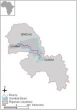
Carte de localisation
Nom de l'organisation
Organization for the Management of Gambia River
OMVG
Adresse
BP2353 Dakar
Téléphone
(221) 8223152, (221) 8225926
Courriel de l'organisation
omvg@omvg.sn
Nom du responsable
Viera Justino
Année de création
Contacts
Données de base
Superficie totale
69900km²
Linéaire de cours d'eau
1 100Km
Nombre d'habitants
Pluviométrie
Varies from 1700 mm/year in Southern mountains to 800 mm/year in the north.
Cultures irriguées
Rice grown on irrigated land is one of the main expanding activities in the basin. The basin possesses an irrigation potential of about 130,000 ha.
Agriculture non irriguée
Varies from 1700 mm/year in Southern mountains to 800 mm/year in the north.
Site Internet
Site Internet
Couverture géographique
Bassin
Pays riverains
| Pays | Superficie |
|---|---|
|
Gambie
|
5900km²
|
|
Guinée
|
13199km²
|
|
Sénégal
|
50700km²
|
Pays
Fonction/mandat
Fonction/mandat
Fonctionnement
Structure organisationnelle
Structure organisationnelle de la coopération
Plan de gestion et programmes d'actions
Monitoring et système d'information
Régles de prises de décision et procédure d'arbitrage
Financement des structures de coopération
Participation des parties prennantes
Historique de la coopération
Bases légales
| Date | Nom du traité | Signataires |
|---|---|---|
|
1889-08-10
|
Agreement
|
France
Great Britain
|
|
1895-02-04
|
Navigation Notes
|
France
Great Britain
|
|
1906-10-19
|
French/British Frontier Treaty
|
France
Great Britain
|
|
1913-09-04
|
Sierra Leone-Guinea Boundary
|
France
Great Britain
|
|
1978-06-30
|
Gambia River Basin Commission
|
Gambia
Guinea
Senegal
|
|
1978-06-30
|
Status of River Gambia
|
Gambia
Guinea
Senegal
|
Challenges
Challenges