Informations générale
Carte de localisation
Nom de l'organisation
Adresse
Courriel de l'organisation
Nom du responsable
Année de création
Contacts
Données de base
Superficie totale
803500km²
Linéaire de cours d'eau
1 658Km
Nombre d'habitants
Pluviométrie
Varies from 200 mm/year to 1800 mm/year with a basin mean of 430 mm/year.
Cultures irriguées
Of the total irrigation potential of 323,000 ha less than 200,000 ha is under irrigation due to limitations on yearly available water.
Agriculture non irriguée
Site Internet
Site Internet
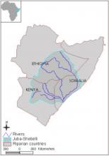
Couverture géographique
Bassin
Couverture géographique
The Shabelli and the Juba rivers originate in Ethiopia and merge in Somalia before entering the Indian ocean. In Kenya there is one tributary of Ewaso Ngiro river which drains the northern side of Mount Kenya, the Aberdares and the North and North East highlands.
Pays riverains
| Pays | Superficie |
|---|---|
|
Éthiopie
|
367400km²
|
|
Kenya
|
215300km²
|
|
Somalie
|
220900km²
|
Pays
Fonction/mandat
Fonction/mandat
Fonctionnement
Structure organisationnelle
Structure organisationnelle de la coopération
Plan de gestion et programmes d'actions
Monitoring et système d'information
Régles de prises de décision et procédure d'arbitrage
Financement des structures de coopération
Participation des parties prennantes
Historique de la coopération
Bases légales
| Date | Nom du traité | Signataires |
|---|---|---|
|
1933-11-22
|
Kenya-Italian Somaliland Boundary Notes
|
Great Britain
Italy
|
Challenges
Challenges