Main informations
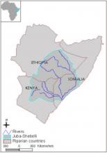
Location map
Name of Organization
Administrative Address
E-Mail
Head of Organization
Year Launched
Contacts
Basic data
Total Area
803500km²
Length of River
1 658Km
Total Population
Total Rainfall
Varies from 200 mm/year to 1800 mm/year with a basin mean of 430 mm/year.
Irrigated Agriculture
Of the total irrigation potential of 323,000 ha less than 200,000 ha is under irrigation due to limitations on yearly available water.
Rain-Fed Agriculture
Website
Website
Geographical scope
Basin
Geographical scope
The Shabelli and the Juba rivers originate in Ethiopia and merge in Somalia before entering the Indian ocean. In Kenya there is one tributary of Ewaso Ngiro river which drains the northern side of Mount Kenya, the Aberdares and the North and North East highlands.
Riparian Countries
| Countries | Area |
|---|---|
|
Ethiopia
|
367400km²
|
|
Kenya
|
215300km²
|
|
Somalia
|
220900km²
|
Countries
Function/mandat
Functions/Mandate
Organisation
Organizational Structure
Organizational Structure for Cooperation
Management Plans and Action Programs
Monitoring and Information Systems
Rules on Decision-Making and Procedure for Dispute Resolution
Financing of cooperation structures
Stakeholder Participation
Historical Record of Cooperation
Legal basis
| Date | Treaty name | Signatories |
|---|---|---|
|
1933-11-22
|
Kenya-Italian Somaliland Boundary Notes
|
Great Britain
Italy
|
Challenges
Challenges