Main informations
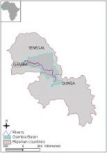
Location map
Name of Organization
Organization for the Management of Gambia River
OMVG
Administrative Address
BP2353 Dakar
Phone
(221) 8223152, (221) 8225926
E-Mail
omvg@omvg.sn
Head of Organization
Viera Justino
Year Launched
Contacts
Basic data
Total Area
69900km²
Length of River
1 100Km
Total Population
Total Rainfall
Varies from 1700 mm/year in Southern mountains to 800 mm/year in the north.
Irrigated Agriculture
Rice grown on irrigated land is one of the main expanding activities in the basin. The basin possesses an irrigation potential of about 130,000 ha.
Rain-Fed Agriculture
Varies from 1700 mm/year in Southern mountains to 800 mm/year in the north.
Website
Website
Geographical scope
Basin
Riparian Countries
| Countries | Area |
|---|---|
|
Gambia
|
5900km²
|
|
Guinea
|
13199km²
|
|
Senegal
|
50700km²
|
Countries
Function/mandat
Functions/Mandate
Organisation
Organizational Structure
Organizational Structure for Cooperation
Management Plans and Action Programs
Monitoring and Information Systems
Rules on Decision-Making and Procedure for Dispute Resolution
Financing of cooperation structures
Stakeholder Participation
Historical Record of Cooperation
Legal basis
| Date | Treaty name | Signatories |
|---|---|---|
|
1889-08-10
|
Agreement
|
France
Great Britain
|
|
1895-02-04
|
Navigation Notes
|
France
Great Britain
|
|
1906-10-19
|
French/British Frontier Treaty
|
France
Great Britain
|
|
1913-09-04
|
Sierra Leone-Guinea Boundary
|
France
Great Britain
|
|
1978-06-30
|
Gambia River Basin Commission
|
Gambia
Guinea
Senegal
|
|
1978-06-30
|
Status of River Gambia
|
Gambia
Guinea
Senegal
|
Challenges
Challenges