Main informations
Haut Commissaire 46, Rue Carnot, BP:3152 , Dakar, Sénégal
| Name | Position | |
|---|---|---|
|
Adama Sanogo
|
adama.sanogo@omvs.org
|
Secretary General
|
Basic data
Varies from 55 mm/year in the valley and delta to 2,000 mm/year in the Upper basin in Guinea with an overall basin average of 550 mm/year.
Rapidly increased after the construction of the Diama dam and is now the main development machine in the basin followed by fishing. The total irrigation potential is estimated at 420,000 ha of which only 118,000 ha are presently under irrigation.
About 80,000 ha of various crops cultivated in the valley and delta.
Website
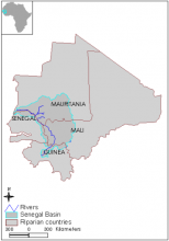
Geographical scope
This covers the Senegal river and its main tributaries, the Bafing, Bakoye and Feleme rivers originating in the Fouta Djallon mountains in Guinea and the Karakoro and Gorgol rivers originating from Mauritania.
| Countries | Area |
|---|---|
|
Guinea
|
30800km²
|
|
Mali
|
150800km²
|
|
Mauritania
|
219100km²
|
|
Senegal
|
35200km²
|
Function/mandat
The OMVS was founded to provide a secure and steadily improving livelihood for the inhabitants of the river basin and neighboring states. The mandate of the OMVS is very broad and ranges from policy-making, regulation to project implementation. Specifically, the OMVS is commissioned to determine the water allocation between the states and sectors, to define the general development policy for the Senegal River and its resources, and to plan and implement projects and monitoring.
Organisation
The highest authority is the Conference of Heads of State and Government which determines the general policies of development and cooperation. The Council of Ministers is the legal representative of the OMVS and determines the general management policy of the river, the development of its resources and interstate cooperation and the financial contributions of the member states. It also approves the budget and Rules of Procedure of the High Commissioner. The Office of the High Commissioner is the executive organ of the OMVS and consists of four departments of Administration and Accounting, Foreign Relations, Technical Matters and the Regional Documentation Centre under a Secretariat.
The OMVS is a comprehensive organization with the goal of fostering economic development in the Senegal River basin through better international cooperation. In the 1972 Convention establishing the OMVS, the Senegal River and its tributaries were declared an “international river.” Dams built under the convention were termed “common works” jointly owned by the three member states. The OMVS has established three consultative bodies: The Permanent Water Commission, the Advisory Committee, and the Regional Planning Committee. The Permanent Water Commission is the consultative body of the Council of Ministers and consists of representatives of the member states. Its main task is the definition of the water allocation among the member states and sectors, namely: industry, agriculture, and transport. The Advisory Committee is the consultative body of the OMVS and is composed of representatives from governments, financial institutions and the OMVS. The Regional Planning Committee advises the OMVS whether the available water resources can meet the regional development plans of the member states. The member states have established National Offices that are represented in the Advisory Committee of the OMVS. They assist the organization in implementing its projects and coordinating its activities in the member states.
Shortly after the founding of the OMVS a program was announced, centred on the construction of the Manantali Dam and another at the mouth of the River at Diamma. The program included three components, irrigation schemes, navigation of the river and energy generation with the construction of a hydropower station at the Manantali Dam. In 1997, the OMVS initiated the Environmental Impact Mitigation and Monitoring Program (PASIE) due to the negative environmental impacts that appeared after commencement of operation of the Diamma and Manantali Dams. PASIE consists of six programs: construction impact mitigation and monitoring, appropriation and right of way, optimal reservoir management, environmental sanitation, monitoring, coordination and communication, and associated measures. In October 2003 the World Bank approved the implementation of the Senegal River Basin Water and Environmental Management Project funded by the GEF.
Any projects likely to modify the river regime, the state of its water, the biological feature of its fauna, and its conditions of navigability and of agricultural and industrial exploitation have to be approved by the member states. To this end, member states must be provided with timely information about any planned project concerning the development of the river
Decisions of the Conference of the Heads of State and Government and of the Council of Ministers are taken unanimously. They are binding upon all member states. If an agreement cannot be reached, the dispute must be submitted to the Commission of Mediation, Conciliation, and Arbitration of the Organization of African Unity.
All member states contribute equally to the budget of the OMVS, each covering one third of the budget of the High Commission. The costs and expenses of investment and operation of the common works are shared among the states in proportion to the benefits derived by each state.
There are no specific provisions stipulated in the agreement. However, within the framework of the PASIE project the possibility for stakeholder participation has been created with the Environmental Observatory. The Observatory is made up of a network of partner organizations including governmental and non-governmental organizations as well as suppliers and users of environmental information. The Observatory is expected to bring together all organizations that provide and collect environmental data, to produce a set of indicators for environmental change, to establish a central database, to support the collection and acquisition of new data, and to periodically publish environmental data.
The foundation for cooperation regarding the riparian states of the Senegal River was laid when the Inter-State Committee for Development of the Senegal River was established in 1963. It was the first agreement granting the Senegal River an “international status.” The Committee was succeeded by the Organization of the Senegal River Riparian States in 1968. The scope of the new organization was broader than that of its predecessor, aiming at the economic and political integration of the four member states. In 1972, the riparian states of the Senegal, with the exemption of Guinea, signed a new agreement establishing the OMVS.
Legal basis
| Date | Treaty name | Signatories | Basin |
|---|---|---|---|
|
1937-12-28
|
Agreement on Tanganyika-Mozambique Boundary
|
Great Britain
Portugal
|
Domani
Ruvuma
|
|
1963-07-26
|
Bamako Convention
|
Guinea
Mauritania
Senegal
Mali
|
Senegal basin
|
|
1970-01-30
|
Dakar Convention
|
Guinea
Mauritania
Senegal
Mali
|
Senegal basin
|
|
1970-01-30
|
Nouakchatt Convention
|
Mali
Mauritania
Senegal
|
Senegal basin
|
|
1972-08-11
|
Convention Creating OMVS
|
Mali
Mauritania
Senegal
|
Senegal basin
|
|
1978-12-21
|
Common Works Legal Statute Convention
|
Mali
Mauritania
Senegal
|
Senegal basin
|
Challenges
Capacity limitation to manage complex water related issues, environmental (land and water) degradation, civil society participation, data and information management and need to strengthen cooperation for basin management and development.